
This post is going to be a little different from previous, as it concerns the recent collision and grounding of the Norwegian frigate HELGE INGSTADT after a collision with the tanker SOLA TS. This is something I take a close interest in, both personally and professionally, and the abundance of open source information allows me to make a few educated observations that some may find interesting.
From the very outset it is important to set several conditions. I have no inside knowledge of what happened, I am working purely from open source information and I want to try and paint a picture of what might have happened that night. The crew are thankfully all safe and it is clear that heroic action was taken to ensure every single crew member was able to disembark quickly. Any analysis in the absence of official information could easily lead to the assignation of blame, but I cannot and will not do so here as we do not have a full picture with all relevant facts. Nevertheless, I believe there is value in providing something educational, that illustrates some of the pressures we place upon our younger watchkeepers and the huge responsibility they shoulder.
The information I have sourced comes from three principle sources. The first is a release of the local Vessel Traffic Service (VTS) radar surveillance data, with radio calls in Norwegian overlaid (link). The second is the same radio calls, without surveillance but with English subtitles (link). A further useful source is a video of the AIS track movements (link). The correlation of these different sources gives a moderately high level of certainty that the tracks displayed are accurate and have not been modified significantly. However, some editing has taken place and the data must still be treated with caution; I will illustrate those cautionary issues as best I can. Other information sources include the International Regulations for the Prevention of Collision at Sea (the IRPCS or ‘Rules of the Road, the maritime manoeuvring rules summarised here), NATO public relations material on Exercise TRIDENT JUNCTURE, and the Norwegian maritime safety service website.
Environment
This took place near Bergen, about the same latitude as the Shetland Isles. The area of water, about 2-3 miles wide, marks one of the northerly approaches to Bergen itself and is controlled by the Fedje Vessel Traffic Service (VTS)(link). A quick search shows the extent of the reporting area (see below); vessels entering this area of water must report in on one of two VHF radio channels and must do so some way before entering the confined waters. An additional observation is that normally in VTS controlled approaches, vessels with serviceable Automated Identification Systems (AIS) would be expected have these systems switched on to enable the VTS to do its job.

The island west of the collision location is Alvoyna in the Oygarden municipality, and the oil terminal at Sture is a busy port that receives large tankers such as the SOLA TS which was involved in the collision. Otherwise the islands in this area are relatively sparsely populated with just 4,900 or so inhabitants across the whole municipality. From that we can assume that there would be few lights at night to mark the shoreline, with the exception of the oil terminal which would be brightly lit. The channel is approximately 2 miles wide but is relatively deep, narrowing south of Sture into a channel little over a mile wide.
The collision occurred at approximately 0400 local time on Thursday 8th November 2018. Sunset the previous evening was at approximately 1623; sunrise would not be until 0821. There was no moon; the moon set at around 1718 the previous day and would not rise until 0847. We cannot be certain of the weather conditions which may have restricted visibility. However, there is no evidence of weather or high seas on the radar picture and if visibility was restricted by rain or fog, a ship would be unlikely to be sailing at high speed.
 Finally the ships involved. SOLA TS is a Maltese flagged oil tanker of 62,000 tonnes. We know she had 23 personnel onboard and after the collision was reported to have little or no damage. Merchant ships are usually well built, especially when carrying petroleum cargoes which if leaked could have devastating environmental consequences; consequently the lack of damage is hardly a surprise. As a result they are sluggish, slow to manoeuvre or accelerate/decelerate. They are not, however, considered to be ‘restricted in their ability to manoeuvre’, a special condition identified in the International Regulations for the Prevention of Collision at Sea – the IRPCS or ‘Rules of the Road’ – this is a condition applied only to vessels which are restricted by their work, such as picking up or laying submarine cables or pipelines, launching or recovering aircraft, carrying out underway replenishment, etc. SOLA TS might have been slow to manoeuvre, but she is not exceptional and is unlikely to have carried any special status. SOLA TS had a tug, TENAX, in company and might conceivably have been considered to be under tow; however, once again no special status is conferred unless the nature of the tow made it particularly difficult to alter course. The tug is more than likely to have been pacing the tanker, probably not connected and likely a precaution for a fully laden oil tanker in narrow waters.
HELGE INGSTADT, by contrast, is a FRIDTJOF NANSEN-class air defence frigate of just 5,290 tonnes. Lightly built for speed and manoeuvrability, warships are invariably less robust than merchant ships, but are more tightly compartmented and have more complex damage control arrangements to compensate.
Narrative
From the video clips above, a rough timeline of the events can be determined. Noting the presence of editing in these tapes, I have avoided trying to extrapolate exact timings. However, relative timing and positional information is still valid.
We know that SOLA TS sailed from Sture Terminal and proceeded north, with the tug TENAX in company. Another tug, AJAX, assisted her departure but returned to Sture immediately afterwards.
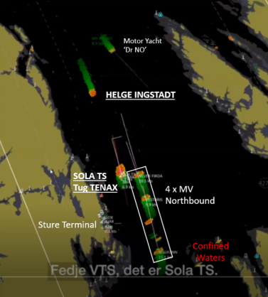
SOLA TS was 0.5 miles north of Sture when the first radio message relating to the incident is believed to have been transmitted, a conversation between SOLA TS and Fedje VTS asking about the identity of a radar contact 2 miles north of SOLA TS, and heading towards her; this is the moment depicted above. The SOLA TS had to turn through 180 degrees when she left the berth and her bridge team may not have seen the HELGE INGSTADT until clear of the terminal; however, her radar would have been expected to detect HELGE INGSTADT in good time and Fedje VTS should have advised her of a fast southbound contact. It is interesting to monitor the third video above (showing only AIS contacts) in which the departure of SOLA TS appears to be delayed until a southbound merchantman is clear.
Fedje VTS initially responds that they do not know the identity of the radar contact and state that the vessel had not reported to them. This is unusual – the Fedje VTS area of operations extends well north of the area and transiting vessels should have checked in. After a pause, Fedje informs SOLA TS that the vessel is probably the HELGE INGSTADT; a few seconds later, contact is established between SOLA TS and HELGE INGSTADT.
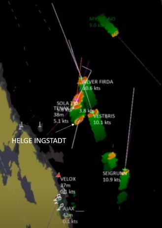
An illustration (not definitive) of what HELGE INGSTADT might have seen looks something like this:

At this point in time, SOLA TS is slowly accelerating northwards at 6-7knots, whilst HELGE INGSTADT is just 2 miles north of her, on a reciprocal course, at 17kts. That’s effectively a head-to-head situation with a closing speed of 24+ knots. Now 2 miles at less than 30mph sounds like plenty of time to assess a situation and react. It is worth highlighting that at that rate of closure the ships had about 5 minutes to act (24kts means you travel 2.4 miles every 6 minutes and 0.4 miles every minute). Let us look at the other factors.
East of SOLA TS was a group of merchant vessels following the channel northbound and overtaking her (4 knots faster) – the ships SILVER FIRDA, VESTBRIS and SEIGRUNN (plus a possible fourth contact not transmitting on AIS). From SOLA TS perspective, these ships severely limit her ability to turn away from HELGE INGSTADT. In theory this should not have been a problem – overtaking ships are required by the IRPCS to keep out of the way of ships they are overtaking (Rule 13). They have, in my view, sufficient safe water out to the east to give SOLA TS more room to manoeuvre, in particular SILVER FIRDA and VESTBRIS. But no request for such room was made over the recorded VHF channel by SOLA TS or HELGE INGSTADT.
Returning to the narrative, SOLA TS called HELGE INGSTADT again and insisted she turn to starboard (in this case, to the west towards the island of Alvoyna. HELGE INGSTADT replied that she could not do so, as to alter westwards would put her too close to the shore (‘obstacles’ or ‘blocks’ in the English subtitles). SOLA TS was insistent but now uncertain, asking again for HELGE INGSTADT to turn to starboard ‘if it is you’. By the end of this conversation, the ships are now 1 mile apart, and HELGE INGSTADT is still cruising at 17kts. They are 2m30s from collision.

There is then a sequence of poorly-translated messages where HELGE INGSTADT appears to suggest that she has ‘a few degrees starboard when we passed’. This could mean one of two things – either she has the flexibility to alter her course only a few degrees to starboard, or else she believes that she may be passing the SOLA TS on her starboard side and that a collision is not anticipated, although it would clearly be incredibly close. Whatever the intent, the effect is the same; a very close quarters situation is inevitable.
SOLA TS appears to be resigned to a collision and, after insisting that HELGE INGSTADT has to ‘do something’, states that a collision is essentially inevitable. Subsequent to this, less than 5 minutes after the initial radio hail and with HELGE INGSTADT still at speed, they collide. From the images of the HELGE INGSTADT, the impact of the tanker’s starboard bow on her hangar (midway down her starboard side) is clear, the anchor hawse gouging a deep hole along her hangar side. Crucially, however, SOLA TS was fully laden and her submerged bow has clearly split open the HELGE INGSTADT below the waterline.

The engine room is probably flooded, leading to the reported loss of power. HELGE INGSTADT rapidly loses speed and the actions of her bridge team are immediate, a hard turn towards the shore to run her aground. The speed of that decision is stunning; an immediate recognition of the gravity of the situation, and the only option to keep her afloat. Within 2 minutes of the collision, she is aground. It is possible she drifted ashore under her momentum alone; it is doubtful she had any motive power at this point. After the collision, HELGE INGSTADT requests ‘immediate assistance’ (and does not declare Mayday at any stage), reporting that she had hit an ‘unknown object’.
Note from the screenshot above just how close SOLA TS is to the other merchant vessels. SILVER FIRDA is just clear ahead, but SOLA TS makes a very substantial turn to starboard after the impact, resulting in a very close quarters situation with VESTBRIS who makes a bold alteration of course to port to bail out. Further astern, both SEIGRUNN and the unknown radar trace open out to starboard, although the unnamed contact slows down rapidly, apparently catching SEIGRUNN unawares and the two have a very close quarters situation.
Additional Factors
Automated Identification Systems (AIS)
AIS is a civilian identification system adopted by the International Maritime Organisation (IMO) for the purposes of safety at sea, enshrined in the Safety of Life At Sea (SOLAS) convention. It is the maritime equivalent of IFF for civilian aircraft; mandated for all ships grossing more than 300 tonnes and for all passenger ships, it is a useful aid to navigational safety. It is only as good as the information transmitted, however – position, course and speed should be automatically relayed from the ship’s GPS system, but failures can lead to wrong information being transmitted, and supplementary information such as whether the ship is underway or moored requires manual intervention to change settings.
AIS is not a replacement for radar or a good lookout. The IRPCS mandate that a lookout must be kept ‘by sight and hearing, as well as all available means appropriate in the prevailing circumstances and conditions’ (Rule 5). This is reinforced by Rule 7, which not only restates the requirement to use ‘all available means appropriate’ to determine if risk of collision exists, but also drills into the use of radar information as well. Nowhere in the Rules is AIS mentioned, although it is clearly implies by the phrase ‘all available means appropriate’. The ‘so what’ is that navigation without AIS is inadvisable, but not incorrect. AIS data is usually plotted on an electronic chart and/or radar display, thus providing a combined picture of all available navigation information to the mariner.
Although most warships carry AIS systems, national caveats on their use are perfectly legitimate – after all, there’s no point in operating stealthily at sea if you broadcast your position. During TRIDENT JUNCTURE it makes sense for warships to operate with AIS switched off, especially if repositioning to set up particular attack phases or if trying to evade surveillance by the opposition. Such activity is routine in Royal Navy exercises including FOST training on a weekly basis south of Plymouth and during the twice-annual JOINT WARRIOR exercise off Scotland.
Nevertheless, it is difficult to understand why, in home waters and in this busy area, a transiting warship would elect not to switch on its AIS system.
Exercise TRIDENT JUNCTURE
TRIDENT JUNCTURE ran from 25 October to 23 November 2018. Taking place in three phases, the second phase was the ‘live’ phase which ran from 25 Oct to 7 Nov, therefore the HELGE INGSTADT collision took place the day after the live phase ended. The third phase was a command post exercise, not requiring live assets (more of a simulation than a live exercise). At this stage it is not known whether HELGE INGSTADT was still participating in the exercise; if she was, then running AIS silent through coastal waters is a valid tactical manoeuvre, and could potentially have been combined with a radar and emission silent policy; in open waters, a warship could even operate without lights, or with lights dimmed or rigged in ways to suggest she is in fact much larger or smaller than might otherwise be estimated.
However, this sort of tactical deception in narrow, confined and/or busy waters requires planning and perfect execution in order to be safe and successful. At minimum in an equivalent RN platform, it would have required a qualified navigator and a command-qualified officer (CO or competent XO) on the Bridge augmenting the standing watch team, with additional personnel closed up on the engines, steering and radar plots.
GPS Jamming
There has been much speculation as to whether GPS jamming, whether Russian or otherwise, could have force this incident. The answer in my view is no on two counts.
First, the AIS data and radar plots remain correlated throughout. If there was GPS jamming ongoing, we would expect to see the two data sources diverge. In the absence of that, I do not believe that jamming was taking place.
Secondly, even if GPS jamming was ongoing, the fundamentals of navigation require that we use visual and radar information above all others; this forms the basis of bridge watchkeeper training. This is unaffected by GPS jamming, and the situation would be clear to any and all vessels in the area. The radio conversation clearly refers to an unknown vessel initially, which was plotted on radar and was probably sighted visually as well; it could not have come from a GPS-derived AIS source.
Analysis
When considering collisions such as these, the first reference is always the IRPCS, the ‘Rules of the Road’. This situation under the IRPCS is a Head On Situation (Rule 14), that is ‘when two power driven vessels are meeting on reciprocal or nearly reciprocal courses so as to involve risk of collision’. Neither vessel benefited from any special status under any other Rule, and both vessels are required to ‘alter her course to starboard so that each shall pass on the port side of the other’.
SOLA TS is a large ship that is relatively unwieldy at low speeds. At these close ranges, her speed of reaction would have been substantially slower than that of HELGE INGSTADT; nevertheless, she was obliged to take action to avoid collision under Rule 14. However, SOLA TS was hemmed in to starboard by the overtaking group of merchant vessels; altering course to starboard was possible but extremely limited given the proximity of SILVER FIRDA and VESTBRIS. By itself, that manoeuvre would not likely have been sufficient to avoid the close quarters situation but it might have opened up enough of a gap for HELGE INGSTADT.
Turning the other way, however, was fraught with risk. If HELGE INGSTADT obeyed her imperative under Rule 14 late and turned to starboard, a port turn by SOLA TS would have kept the ships on a collision course. Therefore SOLA TS was limited in her options, which probably explains her insistence that HELGE INGSTADT be the one to move. Although understandable, it does mean that SOLA TS is not absolved of all responsibility, as the ‘catch all’ Rule 2 of the IRPCS elegantly describes. And if these constraints were weighing on the master of SOLA TS’ mind at the time, you might expect more forceful and detailed instructions over the VHF channel.
HELGE INGSTADT should have had more options available to her. She was not confined by overtaking traffic, and under Rule 8(e), ‘if necessary to avoid collision or allow more time to assess the situation, a vessel shall slacken her speed or take all way off by stopping or reversing her means of propulsion’. As a warship of her type, HELGE INGSTADT is expected to be more than capable of reducing her speed rapidly; indeed, she could have reversed course in the time available. Since she declared she was unable to alter her course to starboard, a reduction in speed should have been the first option to be taken in order to allow more time, and later to avoid collision. An alteration of course to port would have taken her across the bow of the northbound merchantmen, itself a risky manoeuvre but viable given the greater area of navigable water to the east.
Assumptions
- All ships were maintaining an appropriate lookout, visually and by radar.
- None of the ships involved were classified under any special condition under the IRPCS.
- All ships were in sight of one another.
- As this was at night, all vessels had the requisite navigation lights switched on at the mandated brilliance.
- There is no other radio traffic of significance other than that heard in the videos. The channel concerned is assumed to be VHF channel 16, the international safety channel.
Contributing Factors
- HELGE INGSTADT appears to not be transmitting on AIS, reducing other ships awareness of her position.
- Fedje VTS is unclear about the identity of HELGE INGSTADT at the beginning of the incident, suggesting they were not fully aware of her position and therefore did not warn the SOLA TS or other traffic of her presence earlier.
- SOLA TS was at low speed, fully laden and under tug escort, but was otherwise not restricted in her ability to manoeuvre.
- HELGE INGSTADT was cruising at 17kts throughout and did not slow down prior to collision, even when obliged to do so under Rule 8 of the IRPCS.
- The merchant vessels SILVER FIRDA and VESTBRIS, transiting north, did not manoeuvre at any stage to allow SOLA TS room to alter to starboard as the close-quarters situation with HELGE INGSTADT develops.
- Communication between HELGE INGSTADT and SOLA TS does not make clear any limitations placed on SOLA TS in terms of speed, manoeuvrability or the proximity of overtaking traffic.
What we do not know.
What we do not know is as important as what we do. We have to assume some of the information covered above is suspect or has been edited; nonetheless, much of it hangs together across three different sources.
We cannot be certain of the weather conditions which may have restricted visibility. However, there is no evidence of weather or high seas on the radar picture and if visibility was restricted by rain or fog, a ship would be unlikely to be sailing at high speed.
We do not know if HELGE INGSTADT was operating under any particular defect or operational condition (such as having a towed sonar system deployed) that affected either her manoeuvrability or her speed. However, none was declared over VHF. We similarly do not know whether SOLA TS was operating under any special condition authorised under the IRPCS.
Conclusion
I cannot and will not assign blame to anyone in this situation, as I do not possess all the facts and I am using potentially questionable information. However, I would have questions as to why HELGE INGSTADT, faced with a narrowing channel and 4-5 merchant vessels all on reciprocal or near-reciprocal courses, did not reduce her speed to allow time to either assess the situation fully and take action, or avoid collision. The formal report will determine the correct facts of this case.
However, for all mariners I hope this is a useful study that could be useful when navigating in similar situations in future. It is certainly something I will have my future watchkeepers study when they are keeping the ship safe overnight.

Thank you for a very interesting, and thoughtful, blog. I wonder, what was the tidal situation? It was full moon the night before, so it was very near a spring tide. Much of my boating has been on major tidal rivers and the energy, and speed, of an incoming flood tide is far in excess of anything on the open sea. Especially when a restricted channel narrows even further. For example, on the River Trent a large tide comes in for two and half hours, and ebbs for ten hours. All vessels will feel the tidal force. If such a tide was incoming the warship would have lost a considerable amount of steerage, and her speed would be greatly increased.
Secondly, are there separate marked channels? I ask because the three northbound motor vessels were far to the west, leaving wide navigable waters to starboard? On narrow channels a lead vessel tends to set the track and others follow, especially on a dark night when they simply follow a stern light in front of them.
Thank you again. Christine.
LikeLike
Christine, thank you. I don’t have access to the tidal stream data for that part of Norway, but experience suggests it’s probably only a knot or so. Given that this area is relatively close to the open sea, it may well be that current is more of a factor – equally, this part of the world is known for odd freshwater runoff flows.
However, that said the power and manoeuvrability of both vessels would probably be sufficient to render the tide a secondary or tertiary factor. The channel is a mile wide at it’s narrowest and very deep, over 50-100m in places, so very different to the Trent by comparison. Norway is a fascinating place to navigate.
I don’t know if this is formally classified as a narrow channel – I couldn’t see much in the way of buoyage though I don’t have access to an accurate nav chart of this region (I have sneaked a look at a friend’s pocket nav app!). The channel is mostly in excess of 2 miles wide in the north, but south of Sture, where the merchant vessels have come from, the channel narrows considerably to less than a mile – I believe that is why the four merchantmen were in column. I do think they could have read the situation, however, and given SOLA TS a bit more room.
If this isn’t a narrow channel, the requirements under Rule 9 would not apply and although keeping over to starboard would make sense, it may be that their courses were dictated by their next destination. Still, the four overtaking vessels kept in a clear column and had it not been for SOLA TS sailing when she did, HELGE INGSTADT could have had a clear run through the gap. There’s a lot of unfortunate timing here.
Thanks for taking the time to comment, do come back if you disagree!
LikeLike
Hi,
Just to clear a few facts with the data available to us:
Regarding GPS jamming you wrote this:
“First, the AIS data and radar plots remain correlated throughout. If there was GPS jamming ongoing, we would expect to see the two data sources diverge. In the absence of that, I do not believe that jamming was taking place.”
GPS jamming / spoofing claims are rather expected to be of targeted and highly localized nature, either towards the frigate and/or the tanker (there is an experiment with a $80M yacht https://www.nextgov.com/defense/whats-brewin/2013/07/university-texas-team-hijacks-80-million-yacht-cheap-gps-spoofing-gear/67625/), and not universal affecting the GPS signals of a whole region, which might trigger complaints & alerts. Here the AIS data & radar images are neither sourced from the frigate, nor the tanker. So theoretically, the AIS data and radar images being inline with Fedje VTS’s or Suture Terminal’s screens (which may not be altered at all) does not leave out a targeted spoofing attack possibility.
When you overlay the screenshots of 2 radar images with their visible course vectors, one from 1:45 of the VG video and the other just before the collision at around 3:18, you can see that Helge Ingstad did indeed turn around 6° port rather than starboard, and Sola TS turned 5° starboard. According to the universal maritime rule 14/a both are expected to turn starboard to avoid a head-on collision.
Another overlay of the frigate’s approximate location exactly when they say “if we turn starboard then we’ll get near the shore/reef etc.” (“Da går vi for nærme båkene.” at 2:17 of the VG video.) with the NHS nautical chart #120 (https://www.nauticalchartsonline.com/chart/zoom?chart=NHS120 ), you will see that Helge Ingstad’s starboard is clear. No reefs, no beacons, no shallow points in the immediate vicinity on their starboard side. They are considerably (app. 0.65 miles) away from the shore, and their course southbound, the closest shallow point is at 0.9 miles & 25° starboard, being 19 meters deep, even that should not be a problem for a frigate with 7.6m draft.
4 minutes 30 seconds after the collision Helge Ingstad’s command “We’ve a situation, we ran into an unknown object.” They are still unaware that they hit the oil tanker, they were in communication with.
Also, until the 52n second of the video (0:52) the unknown ship doesn’t have a speed vector on the radar, but only a trace. Only then, it appears at 0.0 knots, gradually shifting up to 17.4 knots by 1:30. The unknown ship —Helge Ingstad—was clearly not accelerating , only that its speed became fully visible in the radar within these 36 seconds (probably a stealth navigating feature partially turned off).
All in all, their uncompromising speed inner fjord, their unconventional maneuver port-side, their claim to hit the shore in case of a starboard turn, their stubbornness, and their complete unawareness & shock after the incident, indicate a serious loss of situational awareness, if not a total blindness.
Another fact we know is that NATO declared that the frigate was on inner fjords navigation training during the incident. So they may be assumed to be on duty, not on night watch either. https://mc.nato.int/media-centre/news/2018/snmg1-ship-accident-at-sea.aspx
LikeLike
Very interesting. Many thanks for looking at all this source material so closely.
It certainly seems that manoeuvring the frigate at 17 knots probably wasn’t a great choice.
It also seems that having the AIS off maybe didn’t make that much difference in the end.
Given the conditions, I suspect that the bridge crew of the frigate were primarily navigating by visual reference (at night) and might have suffered from some level of optical illusion; it is the only explanation for the level of complacency their radio calls seem to reveal.
They also seem to have been more concerned about available depth to starboard than their position and course justified, in other words reduced situational awareness.
Furthermore, since the damage was on the starboard side of the frigate, they were either on a course that was in violation of the colregs or – more likely – the optical illusion became apparent at the last second and they swerved to port and into the path of the tanker, thinking they could not turn to starboard due to shoal water.
In this manoeuvre they would have been caught out by the fact that the axis of turn is the rudders, not the bow or the bridge. The same thing caught out Costa Concordia, another case of close quarters high speed manoeuvring that didn’t end so well.
This would explain why it seemed plausible to start the manoeuvre; the strike is on the stern quarter. From the bridge it would look like there was room – and there was – but the stern sticks out a further 70 meters or so.
This concern about shoal water also ties in with the one really good move they seem to have made, which was a lightning fast assessment of the level of damage and the decision to run the frigate aground. That is a manoeuvre which no captain is really ever ready for and it takes time to arrive at it because the individual has to overcome disbelief first. But they knew exactly where to go and that would have saved them precious seconds.
-David
LikeLike
Thank you – agree with all your points!
LikeLike
This small and highly manoeuvrable warship was entering a narrowing waterway busy with commercial shipping. The obvious question to ask is, why on earth was the warship going so fast? It was a miracle that there were no deaths or injuries.
LikeLike
When in doubt, reduce speed or take off all way.
LikeLike
A very generous conclusion! Helge’s OOW/CO were clearly at fault. There was ample navigable water to starboard, and also plenty of time to stop, or turn around, or make a bold alteration of course to port to cross ahead (not ideal but better than colliding).
When you look at the actual tracks, this was not a head-on situation but a (fine) crossing situation. Sola was the stand-on vessel, and stood on. Helge’s plot would/should have shown the crossing situation, and I expect Sola’s did, as her radar will have had speed/course markers.
A point of detail – Helge went aground 473 seconds after impact. Her residual way almost certainly carried her most of the distance (the maths fits), and she probably drifted the last couple of hundred yards. It looks very much as if she was not closed up below, given the speed with which she half-sank, and then fully sank later.
ThreePointFix
LikeLike
Hi JGD, I am conscious of the fact that we do not have all available information, and I think it is inappropriate for me to assign blame. I also disagree about the crossing vs. head on situation – I don’t trust the radar vectors to give that fine a distinction, and in any case if in doubt a head-on situation should be assumed.
LikeLike
Good point on the assumption, which would apportion some of the blame to Sola but it seems to me an enquiry will still give most of the responsibility to Helge.
I’m not assigning blame – just trying to form a professional view on how the enquiry will assign blame. There’s always the “what if it had been me” question lurking in the narrative.
LikeLike
One sad add – the collision would have been avoided if Helge had altered to port only three or four seconds sooner – Sola impacted about 100 feet forward of Helge’s stern, and their combined SOA was 50 feet per second. One can see why the OOW did what he did, but it was still completely contrary to basic ROTR.
LikeLike
There is no evidence that the Helge Ingstad, HI, was seriously damage below waterline. There are no photos/films of the hull below waterline taken by divers. Maybe only one watertight bulkhead was damaged in the waterline so that two compartments were up-flooded resulting in immediate Black out. One generator room was flooded and there is no info about a second generator room. The ship should have survived that. But it appears that progressive flooding of many other hull compartments took place through openings in the bulkheads with the result that the ship slowly lost buoyancy and stability and sank in shallow waters close to shore. There is no information that bilge pumps were used. IMHO the causes of incidents are sloppy crew on HI and bad, unsafe design. I look forward to the removal of the wreck – lift it on big barge – so the actual hull damages can be seen.
LikeLike
Hi Anders. Having seen some of the damage on HELGE INGSTADT now she has been lifted, are more or less convinced of your views above?
LikeLike